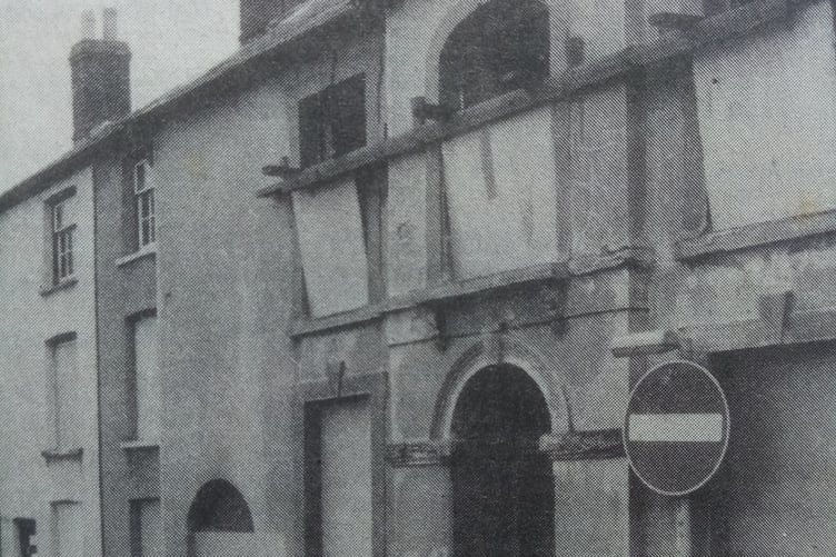
FOLLOWING on from the demolition of Castle Street and Tudor Street, the houses built in the Grofield area of the town were next on the agenda.
This open land was originally known as the Grove Field that was owned by the Baker Gabb family of Abergavenny, and sometime after 1868 became available for development. Baker St., Trinity St., Victoria St., Princes St., Regent St. and Pant Lane were all created to house the ever-growing population.
Most of the development was completed by 1875, but now 90 years later the county planning officer, James Kegie, decided that it was the time for change.
He said: “The proposed redevelopment plan of Abergavenny will not mean that a team of bulldozers will be let loose to lay the town low. It will be a rigid plan to which everyone must confirm but a framework in which private enterprise will play its part.”


More specifically, he put it as: “An evolutionary plan for making private and public enterprise fit into a master-plan. This is not a plan to destroy the central area of Abergavenny, and it will not be redeveloped like a blitz town. It will become a more pleasant place and will fit itself better to the 20th Century.”
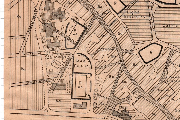
Part of the proposals were to demolish the buildings on the left-hand side of Lower Castle Street to provide two-way access into the redeveloped area and be part of a distributor road to the western side of the main street.
A new road would be built from the junction of Tudor Street and Baker Street that would cut across Trinity and Victoria Street to meet up with the Merthyr and Brecon Roads.
The eastern part of this ring road would be via Monk Street and the Hereford Road where the lane alongside Bailey Park would be widened and extended into Park Road.
This road would then be re-routed past an old chapel, that is now Tescos, by knocking down some shops on the corner of Pen-y-Pound.
The map shows that the new road would then go behind the Baptist church and meet up with the western part of the ring road.
This scheme did go ahead but a change was made to site the road in front of the Baptist church instead of going behind it.
All existing roads between Lower Castle Street (the Angel corner) and the Tesco end of Frogmore Street would become pedestrian precincts – a traffic-free area – surrounded by the main shopping area.
This idea also came to pass but there had to be some sort of vehicle access allowed due to limited delivery facilities at the rear of the businesses in the main street.
The county planning officer went on to say: “The overriding concern of the local authority and the local planning authority must be to make Abergavenny a more attractive and efficient centre of town life, safer and more convenient for all who use it, but at the same time retaining and indeed enhancing the character of the town.”
It was estimated that 10,000 people from within the town and 15,000 from the surrounding areas would use the town centre for goods and services.
Future traffic flows were anticipated from an increase in population, increased affluence and mobility, growth of car ownership and the subsequent increase in their use.
The general policy for the shopping areas was to provide a continuous retail frontage with office and residential accommodation on floors above the shops.
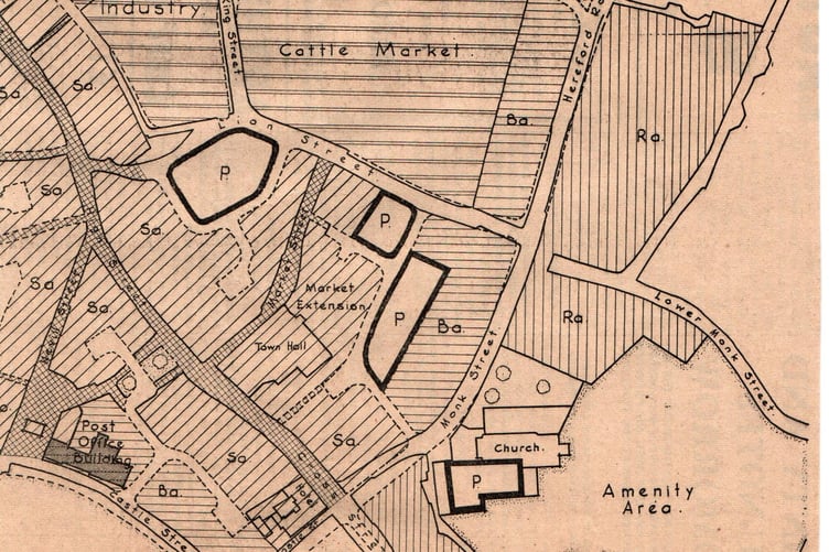
The cattle market was expected to grow in the future and appropriate land had been allocated for this purpose.
Land was already held by the local authority for an extension of the retail market and this has been taken into account.
The part of Tudor Street by the King’s Arms had a particularly pleasant aspect and it was important that any new buildings on this frontage were of a design and scale that is appropriate to this very fine site.
One specific proposal was for a Post Office and telephone exchange to be built there and this was completed around 1968.
Car parks were planned to accommodate 2240 vehicles and any one of them could be turned into multi-storey units should the need ever arise in the future.
The plan also said that the present bus station is badly sited and a new bus pull-in would be provided on the site of the existing police station in Baker Street.
A simplified plan of the scheme appeared in the Abergavenny Chronicle of the 22nd of January 1965.
Alderman George Tranter, who had been a borough councillor for 29 years, said: “That while many features of the proposed redevelopment plan looked attractive, the financial and long-term effects on the town needed careful examination.”
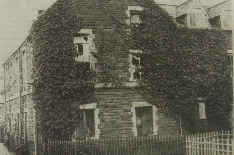
Over 200 people living in Grofield signed a petition condemning the ‘fantastic proposals’ involved in the redevelopment of the town centre.
Scores of people who had bought their homes and had spent large sums of money on improvements were naturally anxious for the safety of their property, but they were recently assured that properties in the ward would not decrease in value if the plans were put into operation.
A newly formed Civic Committee commented that the proposed new road starting in Lower Castle Street would destroy a very important social and religious centre around Trinity Church.
Many letters were published in the Abergavenny Chronicle. One read, “I suggest that the Abergavenny Town Plan should be scrapped as it would only benefit contractors and property speculators. The welfare of affected residents and small businesses will count for nothing at all and other areas of the town will be affected later on if this plan is not scotched. The official machine cares not two hoots for human welfare. To the ordinary inhabitants of Abergavenny, I say: Tell all Abergavenny Councillors that if this plan goes through you will never vote for them again.” Abergavenny Civic Society were also firmly against the proposal to build a new road through Grofield saying that this area should remain residential."
Much debate must have taken place over the next five years as the Chronicle of the 8th of January 1970 reported that a 12-year plan to demolish more than 100 houses in a dozen streets of Abergavenny had been approved by the Borough Council.
The streets affected were in Ross Road, Lower Monk St, Commercial St, Lower Castle St, Tiverton Place in Lion St, Victoria St, Pant Lane, Princes St, Merthyr Road, Magnolia Terrace and Chapel Road.
The time period would start in 1970 and finish in 1983. The plan was said to bring a new lease of life to the ageing Grofield area and wholesale demolition had been rejected. It was hoped that the majority of the houses in the area could be preserved. The council’s own housing would accommodate the people whose properties were demolished as they have in excess of 1500 properties.
In addition, the borough engineer was looking for land that could be used for light industry as several recent applications had been turned down.
The Town Clerk, Mr. Graham Cummings, told the Chronicle that: “The people for whom the Grofield area is home will be asked to help decide whether or not the scheme is right for their district – and whether they would be willing to help improve their homes and their surroundings. Although most of the properties involved had been built before the First World War, wholesale demolition had been rejected. Grofield has a sense of place which is worthy of conservation.”
The widening of Lower Castle Street and the development of a distributor road was, however, given the go ahead. Other short-term proposals included the building of new local government and office buildings at Tudor Street on existing car parking areas, extending the grounds of Park Street school to provide more play space and adapting Grofield School, after closure, for community use, such as an adult education centre.
Mr. Cummings also said that a warning had been given by the county planning officer, Mr. Kegie, that if the residents of Grofield could not agree to work together for the benefit of the area the plan could not be realised and progressive decline might result leading eventually to the need for total renewal.
A public meeting was held two weeks later to discuss the report. The meeting was held in Trinity Church Hall and there was not enough room for all the people who wanted to get in.
The county planning officer, James Kegie, gave a new variation of the plan inasmuch as improvement grants would now be available in a bid to save about 500 houses from demolition.
The debate that followed became very heated and Mr. Kegie is recorded as saying: “If you don’t want to take this seriously, let’s all go home and let the Grofield area look after itself!”
In 1974, Monmouthshire County Council published an article in their magazine, Gwent Review, reported that a census taken in 1961 revealed that only half the houses in the Grofield area had exclusive access to baths and toilets and although car ownership was below the average for Abergavenny as a whole, the streets were gradually filling up with residents' cars and visiting shoppers.
The usual solution to these problems was to demolish the properties, rehouse the occupants in tower blocks and use any spare space for car parks. Abergavenny would have been the poorer had this come to pass but that did not happen and the Grofield is still an area of inherent charm, its streets and buildings holding captive the spirit of bygone days. Car parking, however, is still a problem to this day.
What came out of the decision to preserve the area was a partnership between the residents and the Town Council with the full co-operation of the County planners.
Abergavenny was one of the first authorities in the country to designate a whole area of a town as a 'general improvement area' and obtain Government grants to bring the area up-to-date.
Full co-operation was needed and the Council organised a series of public meetings to explain the plan and the result was an encouraging upsurge of enthusiasm leading to the formation of a residents' association.
Houses which lacked basic amenities could be provided with a grant of up to £1500 with the resident being required to contribute 25% of the total cost.
The Council was prepared to lend that money if required. Thanks to this arrangement, the residents of Grofield, far from living in Victorian slums, were able to modernise their homes and 65 out of 89 houses in the scheme co-operated by giving up a small part of their back gardens so that rear access lanes could be constructed to help keep cars off the street. Victoria Street was converted into a cul-de-sac that had an attractive paved area with trees and shrubs at the Baker Street end.
The success of the Grofield improvement scheme culminated in it receiving a Prince of Wales Award in 1972. Such awards are only made for significant contributions to the Welsh environment. The assessor reported that: “The scheme has resulted in an area of sound and attractive Victorian housing being sensitively adapted to cope with the pressures of modern living.”
The proposed road improvement along Lower Castle and Tudor Street was dropped and it took over 50 years to achieve Kegie's vision of a 'pedestrian precinct.' New public buildings, such as the police station and magistrates court in Tudor Street, have already been demolished and the sites repurposed.
Dick Cole, now Vice Chair of the Civic Society, was a member of James Kegie's team 1969-74. He explained, "The clearances of older parts of Abergavenny in the 1950s and 1960s, decayed though they were, unsettled public opinion. Hindsight (but not old photos) forgets the state of those areas and there was then no financial incentive for restoration, space was needed for car parks and public buildings and rehousing was easy in council estates north of the town. The 1965 plan was typical of the nationwide ambition for growth and renewal at the time, and Kegie wanted Monmouthshire to emulate the Home Counties. But the government was starting to realise that the clearance and replacement of redeemable homes and the loss of heritage were undesirable and unaffordable.
"By 1970 General Improvement Areas, better home and environmental improvement grants, and Conservation Areas reflected the shift of mood and policy. Clearance of Grofield housing, together with other proposals in the 1965 plan, had clearly roused great opposition.
"By early 1970 Kegie had changed direction and the Borough Council's clearance programme of over 100 homes selected only a few in Grofield and few of these were acted upon. Grofield soon became a General Improvement Area and clearance was eventually confined mainly to the northern side of Lower Monk Street and Tiverton Place. Road improvements that required the clearance of properties in Commercial Street and Lower Castle Street were also later to be dropped. Grofield had a narrow escape. "
Comments
This article has no comments yet. Be the first to leave a comment.